The lowest level to determine the direction is using compass (walking in the woods) and the highest level of navigation is using a scientific calculation and sophisticated equipments (landing on the moon). From the beginning, people navigate and marked their destination with many methods until a civilization happen.
Wilderness navigation can be an invaluable skill when exploring the great outdoors. The best places to explore and go hiking have no roads and lots of vegetation, making it very easy to get lost. If you’ve ever been lost in the woods for any length of time, you’ll know that it’s a very humbling and unpleasant feeling. A little preparation and practice with a few simple navigation tools can help you stay on track and avoid getting lost.
Before you set out on your next walk in the woods, take the time to learn how to read a map, use a compass, operate a GPS, and use the sun and stars to guide you. Below are some of the essential wilderness navigation skills that you can use to survive a wrong turn in the woods.
Know the Major Landmarks
Research the area that you’re going into. Most parks and campgrounds have some known boundary points. For example, the area where we go has a highway on one border and a river on another side. Knowing where I’m supposed to be in relation to these landmarks can help you get back on track. When you’re lost, you often think that you’re headed in one direction…when in fact, you’re headed in the opposite direction. Take some time before your trip to familiarize your group with a map and the area that you’ll be in.
How to Read a Map
Map reading is one of the pillars of wilderness navigation, and like any skill, it gets easier with some practice. Being able to translate the symbols, lines and colors of the map to the actual terrain features in front of you can be confusing sometimes, but it gets much easier after you try it a few times. Most maps will have a legend or key that will show you the symbols used on the map and what they represent. The colors used on maps are pretty standard and represent different types of features, as follows:
* Black: Used for man-made features and cultural areas such as buildings, roads, railways, pipelines, and property boundaries.
* Brown: Used for topographic and surface features such as contour lines.
* Green: Used to show vegetation features, such as woods.
* Blue: Used for water features, such as rivers, streams, lakes, and swamps.
* Red: Used for main roads, such as highways. It can also be used to show special features like a tunnel or survey lines.
Contour Lines
Contour lines are used to connect points of equal elevation. Being able to decipher contour lines and translate them to a picture of the terrain is a handy wilderness navigation skill. Lines that are close together indicate a steep rise in elevation. Often times, maps will label the contour lines with their elevation above sea level. Below are a few examples of what a map will show relative to the actual terrain features that they represent:

The Map’s Scale
Another key element of map reading is the scale on the map. Often overlooked, this scale can help you estimate distances and better plan the timing and route of your hike. Most maps are in a scale of 1:24,000 (standard) or 1:25,000 (metric). For the 1:24,000 scale maps, one inch equals 2,000 feet. For the 1:25,000 maps, 5 centimeters equals 1,250 meters. Look at the scale of your map and use it to your advantage. Many maps will have grid-squares to help assist in estimating distances on your map. Knowing the scale of the map and your pace length can help you get back on track...and back to camp! See the pace counting section below.
Map Care
If you need a map for your next camping trip or hike, than taking care of your map should be a top priority. If your map is not water-proof, be sure to protect it in a plastic bag or case. When you fold your map, take the time to do it properly. If you fold your map a different way each time, the creases will become worn and rip and these areas of the map will be unreadable. Depending on your trip and the type of map that you have, it may be worth your while to have it laminated. Most of the larger office supply stores can do this at a reasonable price.
Pace Counting
If you’re participating in a wilderness navigation or orienteering course, you’ll need to plot and hike through a variety of bearings and checkpoints, and you’ll also need to gauge the distance that you’re covering between each to see if you’re on track. To do this, you’ll count your paces and compare it to the projected distance that you measured on your map.
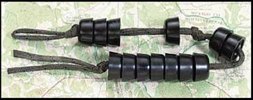
To figure out your pace count, measure a 25 meter length on a sidewalk or path, and count your paces to cover that distance. Multiply this number by 4 to get number of paces per 100 meters. Using a set of simple pace beads (like below), count your paces for the first 100 meters and then slide the first bead down. When you reach 1,000 meters, you slide down one of the top beads and reset the lower beads. It may seam archaic…but it works really well! While the use of GPS units has made land navigation a forgotten skill, it’s nice to have a back-up plan for when the batteries die!
Using a Map with a Compass
A map is necessary in wilderness navigation, but it’s not very useful without a compass to orient yourself. Once you establish the position on the map where you are (Start) and the point where you’re going to stop (Finish), the line between them is your path (azimuth). You can take your straight-edge ruler and lightly sketch this path on your map. If you have a protractor, you can also measure the compass bearing from the angle of your new line and the map’s vertical north line. If not, don’t worry – there’s another way. Place your compass on the map and turn the map until the north arrow on the map lines up with the with the north arrow on the compass (both map and compass should be on a level and flat surface). If you place your compass at the start of your path, and the north arrow on the compass lines up with the vertical grid-north lines on the map, you should be able to look down and see what direction your path is with respect to your compass bearing. Look at the bearing on the compass that lines up with the direction of your path – this is your azimuth. In the picture below, the azimuth is approximately 330 degrees.

Now that you have your azimuth, you’ll want to correct it for declination. Declination is the angle between magnetic north and geographic north. Declination varies by geographic region and usually noted on topographic maps. As an example, the northeastern states of the US have a declination correction of 10-18 degrees, but the states along the Mississippi River have a declination near zero. To correct for declination you rotate the compass on your map to re-orient the north arrow with magnetic north. Many maps will show the magnetic north arrow and geographic north arrows together with the angle defined between them.
When you start your hike, take your compass and orient yourself and the map so that your facing your azimuth (direction of your path). If there’s no visible trail to follow, you’ll want to use your compass to get a landmark to walk towards, at which point you’ll take another bearing to the next landmark. Wilderness navigation can get tricky in thick vegetation or at night and will require patience and multiple bearing checks. Before you depart, remember your back azimuth (your path minus 180 degrees), as this is the bearing you’ll want to take back to the start.
Below is an example of what the compass sight picture would look like on a lensatic compass when taking a bearing on an object:

I hope that these wilderness navigation tips help you as you prepare for your trip. It doesn’t take much time to get better at map reading and compass use. With a little bit of practice, you’ll feel a lot more comfortable before you head out into the woods!
The right to make a copy for personal use is part of most existing publishing agreements. This right is recognised as an important right for the author. Because the right is attached to the author and in most cases well defined, personal use won’t harm the publisher.


